This course delves into the exciting worlds of photogrammetry and remote sensing, equipping you with the skills to extract valuable information about the Earth's surface.
Key areas covered:
- Photogrammetry:
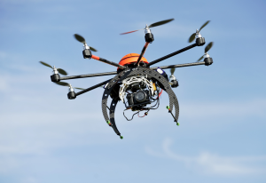
- Principles and theory behind transforming photographs into 3D models.
- Aerial photography techniques and camera characteristics.
- Extracting measurements and data from aerial imagery.
- Applications in various fields like mapping, engineering, and archaeology.
- Remote Sensing:
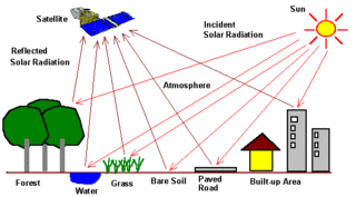
- Concepts of gathering data about Earth from a distance (satellites, airplanes).
- Different types of remote sensing sensors and their functionalities.
- Analyzing and interpreting remotely sensed data (satellite imagery, LiDAR).
- Applications in fields like environmental monitoring, resource management, and disaster response.
Coursework may involve:
- Understanding the geometric properties of aerial photographs.
- Learning about image analysis techniques for extracting information.
- Working with specialized software for processing photogrammetric and remote sensing data.
- Applying these techniques to real-world scenarios through projects or case studies.
By the end of the course, you will be able to:
- Explain the fundamental principles of photogrammetry and remote sensing.
- Interpret and analyze data acquired through aerial photography and remote sensing techniques.
- Apply these technologies to solve problems in various fields.
- Gain a deeper understanding of the Earth's surface features and how they can be monitored and analyzed.
This course is ideal for students in fields like:
- Geography
- Geology
- Environmental Science
- Engineering
- Surveying
- Urban Planning
- Teacher: Jackline Chemutai